Sunday 16 November 2014

Uldale - Walking in the Northern Fells

Longlands - Longlands Fell - Brae Fell - Little Sca Fell - Great Sca Fell - Meal Fell - Trusmadoor - Great Cockup - Over Water


In various situations in life I find myself rooting for the underdogs. It's always uplifting to see someone or something come out on top despite the odds. I have a similar approach when picking a walk to do in the Lakes. Sure a walk up Blencathra, Scafell, Helm Crag or Coniston Old Man is pretty hard to beat. But the Lake District is also full of unsung heroes, fells which don't have the height, views, challenges and legends that the big guns do. Nonetheless they each have a charm of their own, and with such fells you also get a chance to escape the crowds.


This walk around the Back o' Skiddaw meant a chance of a quiet walk on a busy weekend. The Uldale Fells are a group of fells right on the northernmost edge of the National Park, with only Binsey beyond. As far as walking goes these fells are more leisurely than lively. Most of the walks are on grassy slopes, with the occasional steeper climb here and there but overall it's straightforward.

If anything, as they are all fairly similar in look and feel, you do have to keep your wits about you when navigating.


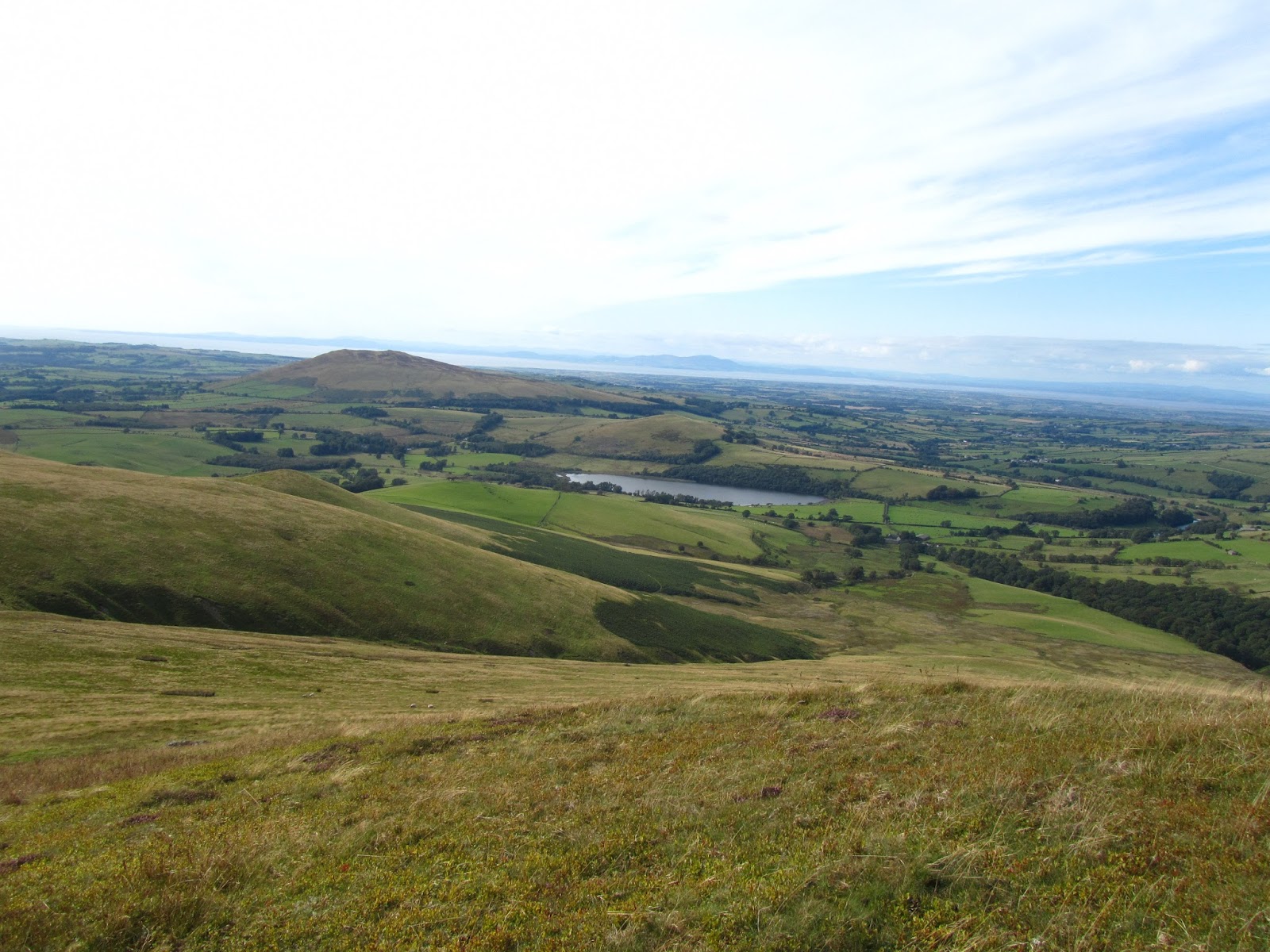
We parked at the small car park at Over Water and made the short walk along the road to Longlands, then headed out on our grassy climb. The walk up to Longlands fell was straightforward without much chance to go wrong and as we got higher the views behind back over Binsey, the Solway Firth and Scotland beyond opened up.


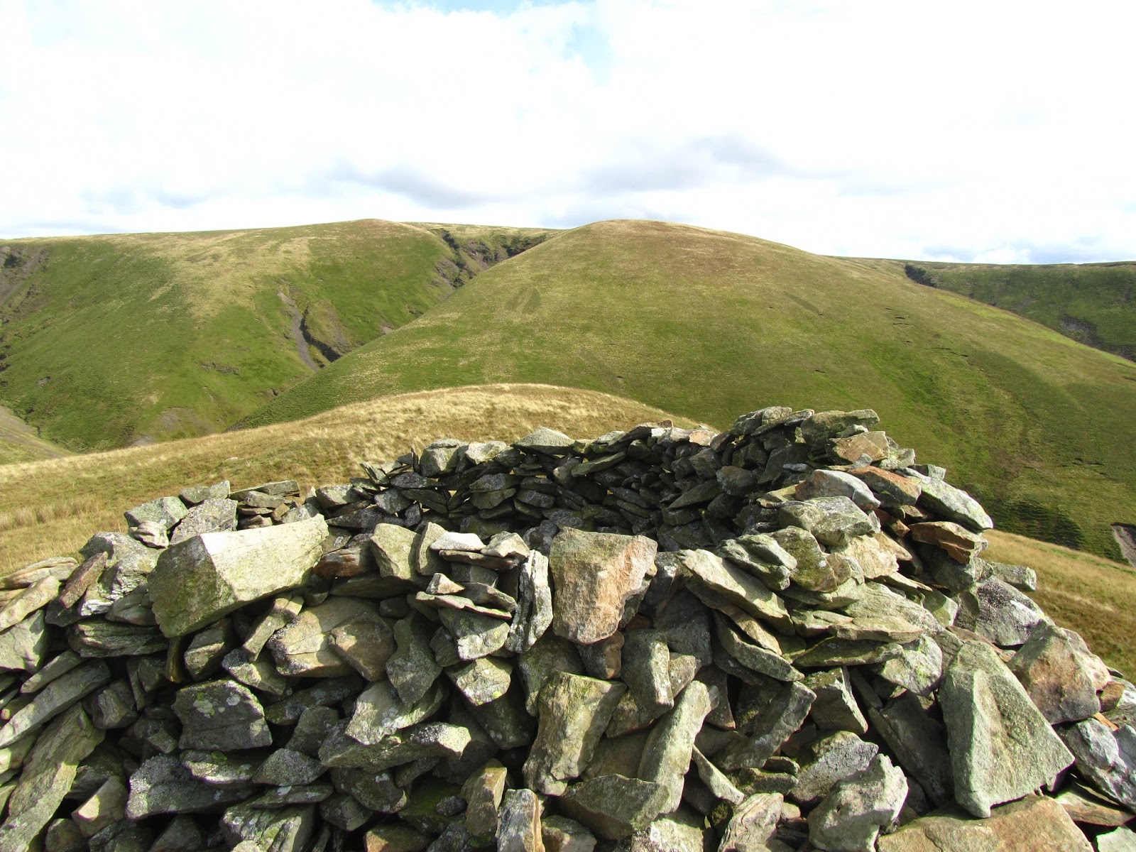
From Longlands Fell our next target was Brae Fell, which on paper looked like a short hop away, but the relatively deep Charleton Gill meant making a detour before the final ascent to reach the bulky cairn that adorns the summit of Brae Fell.


Here we left the views over Solway behind, heading "inland" into the heart of Uldale. It was a straightforward walk across to Little Sca Fell and Great Sca Fell just behind. By this point with the fells are quite similar-looking it can be disorientating, but you do get a wonderful feeling of solitude and serenity.


The next part of the walk saw us head in an almost straight line, coming down from Great Sca Fell, onto Meal Fell and then Great Cockup. The summit at Meal Fell was an interesting collection of lumps, cairns and a decent shelter and so it was here that we settled down for our lunch.


The most challenging part of the walk lay ahead as we had to cross the wonderfully Tolkienesque Trusmadoor to get to Great Cockup.


This ravine actually looked worse than it was, and the purple heather clad slopes made it all very picturesque. Once we had completed the steep climb up it was a simple walk over to the summit of Great Cockup and then down to Little Cockup.


The end of the walk was actually the hardest part, as there didn't seem to be a direct path back down to the road. We headed for what looked like a track towards the farm buildings of Stockdale but it was soon evident that this was private land, and a farmer's wife who saw us soon afterwards was friendly enough but it was clear that we had gone slightly wrong!


Apart from that this was a delightful excursion to the north of the national park and an area what we will be revisiting for sure.

Sunday 26 October 2014

Lyke Wake Walk September 2014


Well this is becoming a bit of a recurring theme isn't it?! For the third time this year, Claire, Dave and myself found ourselves drawn to this crossing of the North York Moors across land steeped in legend and history.


It would be hard to top the June 2014 crossing where we were treated to perfect conditions, accompanied by a beautiful sunset and sunrise, but this journey once again turned out to be a special one.


It was my second reverse crossing, the first time having been done in atrocious conditions back in January. This time, as we set off, once again in the dark, but with incredibly clear skies and reasonably dry conditions underfoot.


Doing the walk in reverse means that the first ten miles require more navigation than expected - what seems like a straightforward walk during the day from Fylingdales over to Ravenscar becomes a lot more challenging at night. Instead of being one simple track headed towards the mast, paths divert off to the left and right all over the place and you have to keep your wits about you. This time, Fylingdales was completely lit up and looked even more alien at night than it does during the day, but this helped simplify navigation beside Little Eller Beck and along the boundary fence of the RAF territory.


The rest of the night passed almost without incident. Dave couldn't resist the urge to lie down on the few pieces of tarmac crossed to gaze up at the firmament, It has to be said this was possibly the most incredible night sky I had ever seen, and just when I thought it couldn't get any better Claire and I got to see a giant shooting start dart across the skies.


Of course no LWW can be completely trouble-free. The minor incidents this time were getting slightly lost on the trek back up Wheeldale, and a short twenty minute game of hunt-the-GPS-in-the-heather, which Claire won, and for which I will be forever grateful! This happened just as the sun was rising - any earlier and we would never have found it.


With the sun rising in our backs as we hit the railway track, we had the beautiful sight of a mist-filled Farndale accompanying us for the next couple of miles. Rather annoyingly, by this stage I had developed a couple of blisters which slowed me down and make the last twenty miles of walking pretty uncomfortable.


As we headed over Bloworth Crossing up to the heights of Round Hill and Urra Moor we passed the first walkers of the day. Oddly enough we only saw Cleveland Way types, I had been expecting to meet at least one or two other groups of people tackling the LWW from West to East on this beautiful day.


A reverse crossing meant that we got to experience the views and scenery of the Cleveland Hills in the daylight. This means a slow rollercoaster ride over tops like Hasty Bank, with the walk through the Wainstones being a particular highlight. By now the blisters were causing me problems, and I had slowed down a fair bit, but the scenery was more than enough compensation for a bit of discomfort.


We had an additional voice of encouragement when the New Lyke Wake Walk Club general secretary Gerry Orchard gave us a quick call to see how we were getting on, during one of the rare occasions of having a strong phone signal!


The Cleveland Hills were bustling with activities, with plenty of people out enjoying the clear weather and the recently renovated Lord Stones site looks to be very busy which is good news for the National Park.


The last few miles of the walk seem to go on for ever on tired legs, but with a reverse crossing the final stretch crosses a variety of terrain as you come down through woodland after Live Moor, crossing farmland before returning to the wooded Coalmire plantation. The last steps as you exit the plantation have now reached legendary status in our little walking group and they don't fail to disappoint every time - an absolute killer!


All that remained was the last section of tarmac to greet the stone at the start/ end, then back to the car at Cod Beck. Minutes later we were enjoying the welcoming atmosphere in the Queen Catherine hotel at Osmotherley, toasting another fine North Yorkshire Moors experience.

Tuesday 7 October 2014

The Hole Of Horcum, North York Moors


I learned about the legend of the Hole of Horcum a while back on a television programme and after having read walk reports in various magazines it has been a place I have been keen on exploring for some time.


On a recent weekend trip to Staithes and Dalby Forest Claire and I headed along the A169, turning onto the steep and narrow lane that took us through the village of Lockton to Levisham for the start of this circular walk. We were not far from Lyke Wake Walk territory and from the top of the Hole we had a great view of the ground we cover on our favourite challenge walk, from Simon Howe to Flyingdales and beyond.


Starting off in the picturesque Levisham, our walk headed onto a path through woodland, skirting the top of a fairly steep valley. The path was quite overgrown in places, but easy enough to follow.


Although we had glimpses of the valley below, it would be some time before we had clearer views ahead and so this is a good build up as you anticipate the glory of this natural amphitheatre.


Coming down the side of the valley, we started the impressive walk that takes you right into the heart of the Hole of Horcum, and it is a very impressive place to be. Either the legend of Wade the Giant who scooped up a giant hole in the ground, or the forces of nature have dug this huge hollow ground that engulfs you as you walk through.


A short steep climb along a heather-clad path brings you out onto the side of the main road, and from here you have fine views over Lyke Wake Walk territory, and a look into the Hole of Horcum behind.


From here we followed the route of the Tabular Hills Walk as it forges its way through the North York Moors.


Although it feels bleak and barren as it can be here, the path is actually a journey through man-made history, with lots of signs telling you of iron age barrows, bronze age dykes, mounds, ditches, Dundale pond and other ancient monuments.I am always amazed at how man's efforts to conquer the landscape inevitably are reclaimed by nature.


From here it was a short walk back along a lane to the top of Levisham village and our waiting car.


Saturday 30 August 2014

Far Eastern Fells - A Howtown Circuit

As part of this year's Wainwright Society Challenge, I made my first journey into to wilds of Howtown and beyond to explore the outer reaches of the Far Eastern Fells.


The purpose of the challenge walk was to tackle one of the ridge routes between two fells, as described in Wainwright's Pictorial Guides, as well as raising money for the Brathay Exploration Group. There are many high level ridges that are almost as legendary as the fells themselves, but I decided to pick a less obvious one. The walk between Arthur's Pike and Loadpot Hill is serene rather than sensational, and whilst other fells will have been rammed on this weekend, I had the place to myself here which was a great feeling.


I started off just outside of Howtown, heading back through the huddle of houses and welcoming pub before hitting the lower slopes of Bonscale Pike. After initially following the path that slants its way up the fell, the guide suggested that there was a more direct ascent to be made, and so I went for it. It has to be said this wasn't a path but a straight slog up the side of the fell, a hands and knees job.


Not the best ascent it has to be said, but my frequent stops to catch my breath were rewarded with the Ullswater opening up behind me. In addition, I made the summit in no time and this meant most of the hard work had been done for the day.


Bonscale Pike and Arthur's Pike both have a lot to offer. As long as you stick to the paths their ascents are relatively simple, and perched on the shores of Ullswater they offer great reward. What's more, both summits are embellished by spectacular beacons, stone handiwork from times gone by.


It is a simple walk from one to the other, with a dip between the two when crossing Swarthbeck Gill, and all the way you are accompanied by fantastic views. I will definitely be revisiting these fells!


From Arthur's Pike I then struck "inland", headed on the wide track that follows the gradual incline of Loadpot Hill. This walk now became one of solitude and serenity, as I did not see let alone encounter another soul in this path, which in the Lake District is a very rare thing. It felt almost like the North York Moors here as I crossed the sprawling mass of land that is Loadpot Hill and Wether Fell. Neither are especially scenic but a look at the map and the references to stone circles, tumuli and Roman forts tell you that this is ancient land and steeped in history. As this is also the route of the High Street Roman road, the path follows in notable footsteps.


Wether Hill has two areas of minor prominence which count as its summits and again, whilst not being especially spectacular, this place is not lacking in atmosphere.


I had originally planned on heading back to the car from here, but I had made good time, so I decided to head down into Martindale and up Steel Knotts. I'm not really sure why, but I decided to jog down the steep path, giving me the tiniest of insights into the world of a fell runner. It meant I covered ground quickly, pausing at a ruined house in Martindale for a spot of lunch.


Steel Knotts is a great little fell, with a craggy summit bearing the magical name of Pikeawassa. Perched just above Howtown, the views from here are as spectacular as you could wish for. From here it was a steep but straightforward descent back to Howtown, sadly still no stop in the pub, but a big smile on my face after a great day in the Far Eastern Fells.

Monday 28 July 2014

Lyke Wake Walk June 2014

Regular readers may recognise a theme. But this is not a repeat, but a tale of another crossing of the North York Moors legend that is the Lyke Wake Walk. Our third crossing in eight months no less. As with our previous two crossings, Dave, Claire and I chose not to use a support party, carrying all our supplies as well as stashing some bottles of water on the moors for later.


For me this was the first Summer crossing, having previously done  the walk in decent to terrible Winter weather. This time around, conditions were pretty much perfect. We picked the longest day of the year, on a decent but not too hot day, after a relatively dry spell.


We set off on Friday night at abut 9:45pm from Cod Beck reservoir just outside Osmotherley. We missed out on a photo at the LWW stone as a large walking group decided to hold a meeting there before setting off on their own expedition. It wouldn't have hurt to move over and let us have the stone for a minute, but these guys weren't about to budge, and so we set off, having a good old moan right from the outset.


I have to say it was a real joy to start the walk in daylight. Not only could we see where we were going, but we were soon treated to a beautiful sunset. There aren't many occasions when Teesside gets described as attractive but this is definitely one of them.


Shortly after we were heading up the first of the Cleveland Hills, making the steep climb up to Live Moor and onto Carlton Bank. By now the light had failed and the headtorches came into action. It was fairly cool for the time of year, ideal walking conditions. We grabbed a bite to eat at the trig point of Carlton Bank before heading down and back up Cringle End.

When we passed the Lord Stones site, we could hear the merriment of people headed home after their night out, but our night was only just starting. We had an interesting moment as we headed towards the Wainstones, walking through a field of cows that were eerily silent as they watched us tramp across their patch. The Wainstones were spectacular even in the dark and this is definitely a place to explore independently of a LWW crossing.


After the Wainstones and the next hill Hasty Bank we had the long steady climb up Urra Moor over Round Hill and over to Bloworth Crossing, before getting some speed up on the railway track. We took the "new short cut", cutting onto the moors to our left over towards Ralph Cross, rather than following the track to the Lion Inn. Although we did lose the path here and there, this was definitely a good time saver. By now the sun was coming up for what promised to be a glorious day.


We stopped for some food at the foot of Fat Betty, before heading along the road to meet the boggy section....


Which was about as dry as you can get! The peat bog was bouncy, pleasant underfoot and great fun to cross. There was the occasional marshy patch and I don't think that the pond not too far from Shunner Howe will ever dry out, but this section was a real highlight of the walk as it was so easy to cross.


The dry ground continued over the road and the path up to Blue Man I' th' Moss was fine too. After Blue Man, it does get rocky making this section possibly the most challenging terrain under foot. The views open right up over towards Flyingdales, but it is a little deceptive as what looks like a fairly flat vista ahead of you hides the fact that Wheeldale is just ahead.


This deep little valley is very scenic, but hard work, with a steep climb down to the stepping stones over Wheeldale Beck. I took the opportunity to take my boots and socks off to dip my feet into the Beck and this was an amazing sensation, totally refreshing. With the sun on our faces and a nice sandwich, this was a beautiful place to stop for a breather.


But the LWW wasn't anywhere near done with us and so we made the steep ascent up to Simon Howe. In the past this has felt like a hard slog - especially when the bank up is wet and slippery, but this time it didn't hurt quite as much. When we get to Simon Howe it really feels like you are well over the halfway mark, and for me this is quite a motivator - all of a sudden the Fylingdales monster isn't a speck in the distance but right there a mile or two ahead.


A look at the clock told us that we were making excellent progress and that also meant that we would get to our pub and hostelry in good time - that's pretty much all we needed to spur us on.There were quite a few people at the layby at Fylingdales a mix of support parties and rail enthusiasts. Just over the road, for an unexplained reason there was a man asleep near the RAF boundary fence. Definitely an odd place and time for forty winks!


The newly cleared path up alongside Little Eller Beck made the section up to Lilla Cross nice and straightforward - the last thing you need when you are exhausted is to go and get lost waist deep in heather!


The dry weather also meant that the rough terrain beyond Lilla Cross was not the heavy wet nightmare that it can  be, but at this point fatigue was setting in and made this section the toughest and dullest part of the walk.


You would have thought that the steep ravine of Jugger Howe that follows would be hell but somehow I don't mind it. I love the scenery here, plus the knowledge that the end is more or less within reach makes it not feel so bad.


However once the ravine is crossed, there is some tough path and road walking to be done and at this stage I knew there were some blisters coming into play. We hit the A171 road, knowing that we only had another couple of miles to go, and that there was a nearby pub with soft beds and cold beer awaiting. Although this last section was quite a killer for myself and Claire as we had both amassed a fair old collection of blisters, it was still a celebratory climb up to the mast.


Sixteen hours and five minutes after setting off from Osmotherley we had once again completed the Lyke Wake Walk, with plans for the next crossing already hatching.


Thanks again to my long suffering partners in crime Claire and Dave. Always a winning team!