Thursday 26 April 2012

Whernside, Three Peaks Completed!

Well, it took a little longer than twelve hours. I didn't clock out and in at Horton-in-Ribblesdale. I didn't even experience the bogs between Pen-Y-Ghent and Whernside! In fact it took me roughly six weeks to complete the Three Peaks of Yorkshire this time around!

The starting point of our ascent

What happened was a failed attempt in February saw me soaked through, and beaten by the weather following the ascent of Pen-Y-Ghent. However circumstance meant I was passing through the area on a couple more occasions recently and so after a recent Ingleborough walk I was able to complete the Three Peaks of Yorkshire - in my own time, on my own terms.

snow piled along the wall on Whernside summit

And what a liberating experience it was! I could choose my routes, decide when and where to stop, take in the amazing surroundings without keeping an eye on the watch, and basically enjoy some exploration of Yorkshire's limestone country.

neighbouring Ingleborough

For the Whernside leg, bog hoppin' Dave and I parked up at Ribblehead. Our original plan was a simple Whernside circular following the crowds, but as we reached the viaduct we decided to head off along another path in order to do a clockwise circuit, against the flow as it were. This path followed the contours at the foot of Whernside, crossing a couple of farms, before heading up the fell.

looking up to Whernside summit

If the approach along the Three Peaks route is a long drawn out affair this path is anything but, and goes fairly steep up along the side of the fell. Having said that there is no scrambling involved, just a steady climb, which has the advantage of gaining altitude quickly.

Whernside ridge footpath

As it happens, we gained the ridge footpath in no time, and soon were reunited with the Three Peakers. We were trying to figure out at what time they will have started and it must have been pretty early in order for them to have done Pen-Y-Ghent and Whernside before midday!

looking over the fells beyond Dent viaduct

With clouds threatening to engulf us we wasted no time going up the ridge and reaching the crowded trig point. From here there are fantastic views all around, over to Ingleborough, down to the ever-present Ribblehead Viaduct and beyond to the Dent viaduct, and the countless fells of the Dales beyond.

the distant Howgill fells

Over the other side of the ridge wall was a great view of the Howgill Fells which remains territory unexplored for me!

tarns on Whernside overlooking Three Peaks country

Coming down we debated on making a detour to Dent but decided this would be a bit of a long detour and with band rehearsals and dj'ing scheduled for later in the day it made sense to head back along the railway to Ribblehead.

Whernside waterfall on Force Gill

We made a detour to go and view the really spectacular waterfalls on Force Gill. This was such a quiet spot, too far off the beaten track for the challenge walkers to visit - another one to add to the list of perfect picnic spots!

Blea Moor with a cloudy Whernside beyond

As we reached Blea Moor a train rolled past, enabling us to see Ribblehead carrying out what it was designed to do, carryiong trains, instead of being merely the target of countless photos, postcards, and Harry Potter pilgrims! From here it was a short walk back to the busy car park at Ribblehead and smiles all round for another great day out in the Dales.

Ribblehead viaduct


Thursday 19 April 2012

Keld to Reeth on the Coast 2 Coast

Here continues our epic Swaledale one-dayer (for part one click here), which took us from the top of the moors at Tan Hill to the centre of Swaledale and the village of Reeth.


This was a day of varying landscapes and I think that made it a really interesting walk.

We pick up at the decidedly fairy-tale picturesque site of East Gill Force, where we stopped for a bite to eat. This is one of the many perfect picnic spots we were to see today!

looking over Crackpot Hall down Swaledale

We headed upwards off the valley path to take in the 18th century ruins of Crackpot Hall. This reminds me, look out for a forthcoming post about Swaledale's industrial past! We had a large walking party ahead of us so there was no need to work out the route, just follow the crowd as they headed up Swinner Gill, past the old lead mine and up East Grain. The skies had clouded over and a steady drizzle was getting us slowly soaked through, but fortunately this soon gave way to much better weather.

one of the Swinner Gill waterfalls

This was a steep little climb up to the head of the gill passing a number of waterfalls, before a complete change of scenery on the tops of the moors. This section reminded us of the railway path section on the Lyke Wake Walk, with nothing but moors in site for miles around.

the upper moors between Keld and Gunnerside Gill

Soon enough we reached Gunnerside Gill, and a climb down brought us out at Blackthwaite Smelt Mill. After a bit of a poke about at this very interesting site we headed upwards to the head of Gunnerside Gill.

the head of Gunnerside Gill

Again this brought us out onto the tops of the moors and a couple of miles of walk along a bridleway, once again taking us past many relics of Swaledale's industrial past. The most spectacular of these was the remains of Old Gang Smelting Mills.

Old Gang Smelting Mills

By now the sun was out and we had warmed up nicely. With the sun out the colours of springtime in the Dales become totally vibrant, with the lush green fields, blue rivers and streams, bright daffodils and specks of white of the newborn lambs dancing in the fields all around.


We came down past Surrender lead smelting mill and this brought us into the almost alpine scenery alongside Barney Beck. This tiny path follows the stream before heading up into the fields and offering once again some fantastic views. Calver Hill came into view before us, this being the hill that stands guard over Reeth, so the end of the walk was not too far away.

Calver Hill

We still had a fine stretch to go, by finally rejoining the river Swale just before the village of Healaugh. Good paths on both sides offer a fantastic riverside walk, with the added fun of stepping stones before fiunally crossing back over to the Reeth side of the river over the suspension bridge.

stepping stones over the river Swale

A final short pull up the hill brings you back to the village green and pubs at the heart of Reeth, perfect!

the square at Reeth

Wednesday 11 April 2012

Tan Hill to Keld on the Pennine Way

Computers eh sometimes you love them, sometimes..... they delete your work for no apparent reason - so here goes, my second write up of this walk!

Tan Hill Inn

As part of our mission to do as many challenge walks as time constraints permit this year, for this month I had decided to do a big Swaledale challenge. I decided to combine two classic long distance paths, taking the Pennine Way down from Tan Hill to Keld and then heading over on the Coast to Coast to Reeth.


We had originally planned to do this the other way round ending up at Tan Hill but unfortunately the bunk barn was fully booked up. I have never been to Tan Hill and Claire is a big fan having been several times on work outings and made firm friends with the pub lamb, Spotty Muldoune!

Nine Standards Rigg in the distance

We parked up at Tan Hill and headed off southwards on the Pennine Way. It was to be a day of changing weather and landscape, and as the pictures show we started off dry but overcast, with vibrant colours across land and sky. From the tops of the moors we had huge views, to the northern Pennines over the A66, westwards to Nine Standards Rigg and with some of the iconic Dales fells visible to the south.

A Swaledale stone barn

The recent dry weather meant that this crossing of the moors was springy rather than boggy and a real pleasure to walk on. Soon enough the pub was just a speck in the distance behind us, and we were in remote territory, with the occasional stone barn for company. Down to the right of us was a tiny road winding its way along the Dale along a little beck where I spotted this packhorse bridge.


Keld soon came into sight, nestled beneath the rounded slopes of Kisdon fell. And with Keld came the switch from the Pennine Way to the Coast to Coast, heading easterly instead of to the south. Coming down the brow of the hill we were rewarded with a fantastic view down the head of Swaledale, surely one of the finest views in the Dales.

Kisdon

Stopping at East Gill Force (thanks to Gary Richardson for the correction! Please look at Gary's fantastic Wainwrights website here) we will pick up on this walk next week. Be warned the weather takes a turn for the worse, so make sure you pack your hat and gloves for the read on!

East Gill Force

Wednesday 4 April 2012

Scafell Pike from Seathwaite farm

This started off with a big up and down before the walk had even begun. We were due to make this trek to the summit of England together with Dave, and had arranged to meet at Seathwaite. So when Dave pulls up in the village of Seathwaite and asks a nearby publican if this was the right Seathwaite for Scafell Pike the landlord replied "You're the first to ask today, but you won't be the last, and no it isn't!"...

the view from Seathwaite

The upside of this is that we had made great time and had reached Keswick early, so Claire and I managed to grab a big breakfast in Booths. The downside was of course, not having Dave with us!


The first mile or so of the walk is amazing, following the river Derwent along the valley until you reach Stockley Bridge. Here you could choose which way to go around Seathwaite Fell, we chose the path that would take us up to Sprinkling Tarn. Our chosen route followed up the side of the spectacular Taylorgill Force.


This was a steady climb up to Styhead Tarn, with the low cloud obscuring the views we should have had up Aaron Slack to Windy Gap between Green and Great Gable. It also meant we could barely see our next target, the huge buttress of Great End.

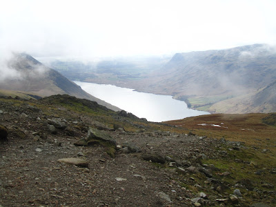
the view to Great End had cleared by the time we returned

We followed AW's directions and veered off from the path, heading straight up the steep grassy slops of Great End, between the crags. Poor visibility meant I think we veered off the proposed route, but the GPS showed we were firmly on track. In fact the GPS proved to be a real winner on this route with visibility right down.

Sprinkling Tarn through the mist

There was a fair bit of scrambling to be done before we made it to the rocky plateau of the summit of Great End, but we rewarded ourselves with a tasty picnic in the summit shelter.

looking over to the Langdale Pikes

From there it was a short but tough trek over to Scafell Pike. The boulders strewn across the path together with the lack of visibility did mean that it felt like we were walking on the moon - albeit a busy moon. As we couldn't see a great deal we didn't bother with the other "Pikes" but headed straight over to the big one. The steep ravine just before the summit was a bit of a blow even though I was expecting it. But a short pull up the other side and there we were, on the highest point in England!

Scafell Pike summit!

The crowds and winds meant it was a short but happy moment, before heading back down towards Lingmell Col. Here I had my first ever good views of Wastwater and some of the more remote scenery in the Lake District.

Wastwater

From the col we headed straight up the slopes opposite and made the short climb up to the summit of our third and final Wainwright of the day, Lingmell. Sadly again the clouds were not on our side, having opened up briefly they closed in on us when we reached the top, so those views of Great Gable and the Scafell range have been saved for another day.

Lingmell

Of course once we got back off the higher ground the skies cleared, and we had some really incredible views all around us. We then hit the celebrated Corridor Route which proved trickier than expected. There were a few places where the path was less than obvious and a tough little scramble up a scree bank too. But the views around Piers Gill were just sensational and I would go back in a flash.


The route was a lot longer than anticipated too, meaning the sun was setting fast by the time we got back to Sprinkling Tarn, and it was more or less dusk when we were back at Stockley Bridge.


But soon enough we were back at the car, and in a 12 mile (or thereabouts) round trip we had taken in the highest point in England, three Wainwrights, some fantastic scenery, a lake, waterfall and some tarns, and a great day out!